
More Heat For Us . . . .
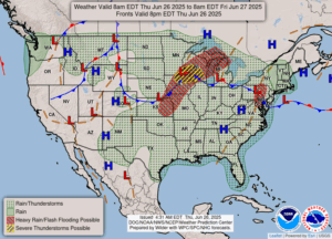
After a much cooler Wednesday, today the heat is back on. Conditions are right for popup thunderstorms, and some could even be severe. This morning was mostly clear but now clouds are moving in. Storm cells are already forming on radar but they are all to our south at this time. I’m sure, with this heat and humidity, we’ll see some by day’s end.
Our 12:15 PM temperature is 85°F, the humidity is 72% and skies are mostly cloudy. Winds are from the west at 2-6 mph, and the pressure is 29.98 in and steady. The dew point is 73°F and visibility is 9 miles. Yesterday’s high was 78°F and the overnight low was 66°F. Average temps for this date are 81°F/58°F. Record temps for June 25 are 101°F (1988) and 40°F (1979). Sunrise was at 5:59 AM and sunset will be at 9:19 PM.
DURAND / OWOSSO FORECAST:
Today: Partly sunny. Highs in the mid to upper 80s. Showers and thunderstorms during the afternoon. Some could be strong to severe. Winds WNW at 5-10 mph. Chance of rain 50%.
Tonight: Showers and thunderstorms likely, mainly early. Some could be strong. Winds SE and 6-10 mph Low around 70°F. Chance of rain 40%.
Friday: Partly sunny with a chance for showers and thunderstorms. High in the mid 80s. Winds SSW at 10-20 mph. Chance of rain 50%.
