
More Rain In The Forecast . . . .
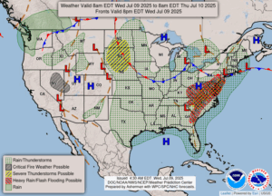
We have had an abundance of rain so far this spring and summer. I’m ready for the usual dry spell that we’re supposed to have this time of year. Today we have a slight chance for some severe storms, and we did have rain overnight . . . .quarter of an inch. At this time, the sun is out but there are plenty of clouds also. None look like rain so far.
Our 12:30 PM temperature is 80F, the humidity is 72%, and skies are partly cloudy. Winds are from the SW at 3-7 mph, and the pressure is 29.99 in and falling. The dew point is 68F and visibility is 10 miles. Yesterday’s high was 83F and the overnight low was 69F. Average temps for this date are 82F/59F. Record temps for July 8 and 108F (1936) and 44F (1954). Sunrise was at 6:06 AM and sunset will be at 9:17 PM.
DURAND / OWOSSO FORECAST:
Today: Partly cloudy with a chance for showers and thunderstorms. Some could have gusty winds and hail. High near 80F. Winds WSW at 5-10 mph. Chance of rain 70%.
Tonight: Partly cloudy with a possible thunderstorm early. Low 63F. Winds light and variable.
Thursday: Partly cloudy. High in the low 80s. Winds N at 5-10 mph.
