Could See Some Rough Weather Today . . . .
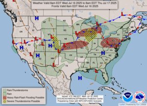
We have a thin cloud cover this morning which will increase as the day goes on. We are in the area for possible severe storms this afternoon and tonight. My area has been very lucky so far as damaging weather goes. Yesterday was very hot and there was still a lot of smoke in the air. Today doesn’t seem as bad. I wish that all this flooding rain would leave the US alone, and move up to Canada and put out those fires. But it never happens that way, does it?
Our 10:45 AM temperature is 80°F, the humidity is 80%, and skies are mostly cloudy. Winds are from the SSW at 2-7 mph and the pressure is 29.88 in and steady. The dew point is 72°F and visibility is 10 miles. The air quality index is till in the unhealthy range at 108. Yesterday’s high was 87°F and the overnight low was 69°F. Average temps for this date are 82°F/60°F. Record temps for July 15 are 99F (1977) and 41F (1960). Sunrise was t 6:12 AM and sunset will be at 9:13 PM.
DURAND / OWOSSO FORECAST:
Today: Increasing clouds with a chance of showers and thunderstorms developing in the afternoon. Some could be strong or severe. High 82°F. Winds S at 5-10 mph. Chance of rain 60%.
Tonight: Becoming partly cloudy with a chance of showers and thunderstorms early. Low 70°F. Winds SW at 10-15 mph. Chance of rain 40%.
Thursday: Mostly cloudy with a chance for showers. High 75°F. Winds SW at 10-15 mph Chance of rain 40%.