Thunderstorms On The Menu . . . .
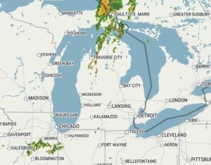
We have another very hot day and we can expect some storms to develop a little later. Clouds are already becoming abundant and there is activity in the northern portions of our state. Maybe a little rain would cool it off some. My husband was complaining that there is so much work to be done outdoors, and it’s just too hot to do it.
Our 1:45 PM temperature is 88°F, the humidity is 53%, and skies are mostly cloudy. Winds are from the SW at 5-9 mph, and the pressure is 29.86 in and falling. The dew point is 66°F and visibility is 11 miles. Yesterday’s high was 92°F and the overnight low was 73°F. Record temps for August 10 are 96°F (2016) and 39°F (1967). Average temps for this date are 81°F/59°F. Sunrise was at 6:39 AM and sunset will be at 8:45 PM.
DURAND / OWOSSO FORECAST:
This Afternoon: Partly Cloudy with a chance for showers and thunderstorms. Some could be heavy. High near 90°F. Winds SW at 10-20 mph. Chance of rain 60%.
Tonight: Mostly cloudy. A 30% chance of a shower or thunderstorm. Winds SW at 5-10 mph. Lows in the lower 70s.
Tuesday: Scattered thunderstorms mixed with partly cloudy skies. Highs in the mid 80s. Winds SW at 10-15 mph. Chance of rain 70%.