Really Feels Like Late Fall . . . .
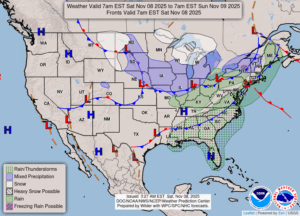
Yesterday will be our last warmer day for awhile. Today feels like late fall or early winter. At least we haven’t gotten any snow yet, but that may happen tonight and tomorrow. We could even see a few inches by the time it is over. It isn’t expected to last, however, since the ground is still quite warm.
Our 1:15 PM temperature is 41°F, the humidity is 55%, and winds are from the north at 4-10 mph. The pressure is 29.92 in and rising. The dew point is 26°F and visibility is 13 miles. Skies are cloudy. Yesterday’s high was 55F and the overnight low was 36°F. Average temps for this date are 50°F/36°F. Record temps for Nov. 7 are 75°F (2020) and 26°F (2012). Sunrise was at 7:20 AM and sunset will be at 5:21 PM.
DURAND / OWOSSO FORECAST:
Today: Mostly cloudy. Highs in the low 40s. Winds NNE at 5-10 mph.
Tonight: Cloudy with snow developing after midnight. Expected accumulations are less than one inch. Winds NE at 0-5 mph and chance of precip is 60%.
Sunday: Mostly cloudy with snow likely. Temp steady in the mid 30s. Winds NNE at 10-15 mph. Chance of pecip 50%. New snow accumulations from a trace to one inch.