Much Colder With Snow Expected . . . .
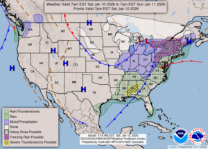
We hit a record temp of 60°F yesterday, but today feels more seasonable. There has been no precipitation yet, but radar is showing it coming from the southwest. We should see a little rain before it turns to snow, and temperatures will be back to normal next week.
Our 1 PM temperature is 35°F, the humidity is 87%, and skies are overcast. Winds are from the east at 4-7 mph and the pressure is 29.77 in and falling. Yesterday’s high was 60°F and the overnight low was 28°F. Average temps for this date are 30°F/19°F. Record temps for Jan. 9 are 60°F (2026) and -15°F (2014). Sunrise was at 8:07 AM and sunset will be at 5:21 pm.
DURAND / OWOSSO FORECAST:
Today: Cloudy with rain and snow showers. Highs in the upper 30s. Winds south at 10-15 mph. Light snow accumulations expected. Chance of precipitation 70%.
Tonight: Mostly cloudy with rain or snow. Lows in the mid 20s. Winds west at 15-25 mph Chance of precip 50%.
Sunday: Snow showers early, becoming mostly sunny in the afternoon. Winds WNW at 15-25 mph with higher gusts possible. Chance of precip 40%.