First Tornadoes Of The Year . . . .
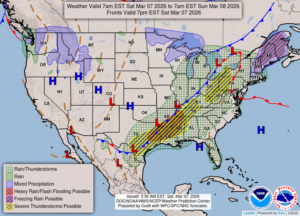
Although we knew that there was the possibility of severe weather, the tornadoes that struck the southwest corner of our state yesterday came as a shock. There were four deaths and numerous injuries. Looking at videos of the damage, I’m guessing that it was probably an EF3 or 4. As for us, we had a lot of rain and plenty of lightning, although there were no close lightning strikes. Three Rivers, MI got the worst of it. We should get more rain today but the severe storms are well to our east now.
Our 12:45 PM temperature is 66°F, the humidity is 78%, and skies are overcast. Winds are from the SW at 14 to 17 mph, and the pressure is 29.51 in and falling. The dew point is 58°F and visibility is 10 miles. Yesterday’s high was 57°F and the overnight low was 56°F. Average temps for this date are 40°F/21°F. Record temps for March 6 are 65°F (2004) and -5°F (2015). Sunrise was t 7:03 AM and sunset will be at 6:33 PM.
DURAND / OWOSSO FORECAST:
Today: Rain likely this afternoon, with falling temperatures. Winds WSW at 15-25 mph. Chance of rain 50%.
Tonight: Mostly cloudy with low temps in the mid 30s. Winds W at 10-15 mph gusting higher at times.
Sunday: Becoming mostly sunny and windy. Highs in the mid 50s. Winds SW at 20-30 mph.