More Storms On The Way . . . .
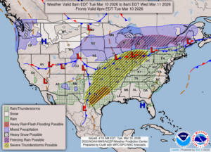
Once again, we are at risk for some pretty hefty storms tonight. The north portions of our state could get freezing rain. Right now it is quiet and there has been no rain so far. We have to travel to Lansing early tomorrow morning, so I’m hoping that it isn’t storming at that time.
Our 3 PM temperature is 47°F, the humidity is 84% and winds are from the NNE at 2-7 mph. The pressure is 29.82 in and rising. Skies are cloudy and the dew point is 39°F. Visibility is 10 miles. Yesterday’s high was 73°F and the overnight low was 44°F. Average temps for this date are 41°F/22°F. Record temps for March 9 are 73°°F (yesterday) and 12°F (2008). Sunrise was at 7:58 AM and sunset will be at 7:37 PM.
DURAND / OWOSSO FORECAST:
Today: Cloudy with a chance of rain after 5PM. Winds NNE at 10-15 mph Highs in the upper 40s. Chance of rain 20%.
Tonight: Showers and thunderstorms. Some could be heavy or severe. Lows in the mid 30s. Winds ENE at 10-15 mph, gusting higher at times. Chance of rain 80%.
Wednesday: Cloudy with rain. Highs in the mid 40s. Winds NNW at 10-20 mph. Chance of rain 90%.