More Snow In The Forecast . . . .
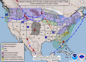
Temperatures have cooled off considerably, and we are now expecting high winds and more snow. Yesterday was very wet and some flooding . There was a lot of standing water on roads and in fields, and the next few day will not be pleasant for us.
Our 2:15 PM temperature is 40°F, the humidity is 40%, and skies are mostly cloudy. Winds are from the west at 2-13 mph, and the pressure is 29.97 in and falling. The dew point is 16°F and visibility is 14 miles. Yesterday’s high was 37°F and the overnight low was 25°F. Average temps for this date are 42°F/23°F. Record temps for March 11 are 64°F (2025) and 10°F (2025). Sunrise was at 7:53 AM and sunset will be 7:39 PM.
DURAND / OWOSSO FORECAST:
Today: High wind warning in effect. Cloudy with the high of 41F. Winds WNW at 10-20 mph gusting higher at times.
Tonight: Increasing winds with snow developing overnight. Cloudy with lows in the upper 20s. Winds south at 5-10 mph, increasing to 20-30 mph. Chance of snow 80%.
Friday: Strong winds at 25-35 mph, gusting as high as 50-16- mph at times. Periods of rain or snow. Highs in the low 40s. Chance of precip 90%.