Nasty Weather On The Way . . . .
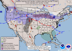
Yesterday was very blustery, and we can expect more of the same tomorrow. We could also see some snow or freezing rain early, then temps will rise into the 60s. That sounds like more tornado weather to me. Our weather lately has been really weird with it going from one extreme to another. I hope that it settles down soon.
Our 3:15 PM temperature is 38°F, the humidity is 39%, and skies are partly cloudy. Winds are calm. The pressure is 30.13 in and steady. The dew point is 14°F and visibility is 12 miles. Yesterday’s high was 43°F and the overnight low was 26°F. Average temps for this date are 43°F/23°F. Sunrise was at 7:51 AM and sunset will be at 7:41 PM.
DURAND / OWOSSO FORECAST:
This Afternoon: Partly cloudy Highs in the upper 30s. Winds light and variable.
Tonight: Increasing clouds and wind. Snow developing overnight with light accumulations expected. Winds will be from the east at 10-20 mph, with higher gusts possible. Chance of snow 90%.
Sunday: A chance of snow or freezing rain. Highs in the mid 60s. Windy at 20-30 mph from the ESE. Chance of precip 60%.