From Record Warmth To More Winter Weather.
The past few days brought a medley of weather., including rain, fog, high winds, and even hail in some areas. Dense fog on Wednesday lingered well into the overnight hours. Yesterday started out with fog, then cleared up a little through the afternoon. Thunderstorms developed bringing hail to some areas. All we got was some distant thunder and a little rain. There was about half an inch over the past two days and just a little drizzle today.
Our 2:45 PM temperature is 34°F, the humidity is 81%, and winds are from the SW at 13-21 mph. Skies are overcast and the pressure is 29.32 in and steady. Yesterday’s high was 46°F and the overnight low was 34°F. Average temps for Feb. 19 are 35°F/17°F. The dew point is 29°F and visibility is 7 miles.
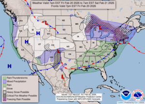
DURAND / OWOSSO FORECAST:
This Afternoon: Cloudy and windy. Chance of rain or snow. Temperatures steady in the mid 30s. Winds SW at 20-30 mph. Chance of precip 60%.
Tonight: Cloudy with a chance of rain or snow early. Cloudy overnight and windy. Winds W at 15-25 mph. Low in the upper 20s. Chance of precip 20%.
Saturday: Cloudy with snow flurries Highs in the upper 30s. Winds W at 10-15 mph, gusting higher at times. Chance of precip 30%.