Foggy And Dreary . . . .
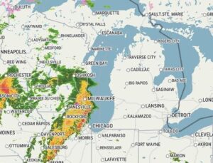
After a very wet Thursday, today looks to be much the same. We are expecting heavy rain and even a slight possibility for severe weather. We had almost half an inch of rainfall yesterday with much pooling in the fields, indicating an existing frost line. The next three days will be very warm with highs reaching much above average.
Our 10:45 AM temperature is 44°F, the humidity is 95%, and skies are overcast with light fog. Winds are from the SE at 0-6 mph and the pressure is 29.95 in and steady. The dew point is 41°F. Yesterday’s high was 41°F and the overnight low was 38°F. Average temps for this date are 40°F/21°F. Record temps for March 5 are 71°F (2024) and -3°F (2015). Sunrise was at 7:05 AM and sunset will be at 6:32 PM.
DURAND / OWOSSO FORECAST:
Today: Cloudy with patchy fog. Heavy rain developing in the afternoon and evening. Winds SSE at 10-15 mph. Chance of rain 70%.
Tonight: Showers and thunderstorms. Some may be strong or severe. Temperatures on the rise overnight to the low 60s. Winds SSW at 15-20 mph. Chance of rain 80%.
Saturday: Showers and possibly a thunderstorm early. Remaining cloudy through the afternoon. Highs in the mid 60s. Chance of rain 80%.,