
More Stormy Weather . . .
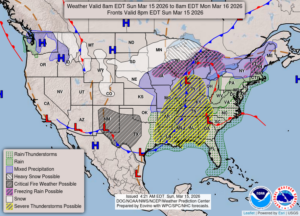
It is expected to be quite a stormy day throughout the nation. The northern states have blizzard conditions while the south could see a tornadic outbreak later today. Here, where I am, we are just expecting strong winds and a little rain. The severe weather is expected to remain south of us although we could get some strong thunderstorms tonight.
Our 4 PM temperature is 51°F, the humidity is 74%, and winds are from the ESE at 5-13 mph, and the pressure is 29.39 in and falling. The dew point is 34°F and visibility is 13 miles. Yesterday’s high was 39°F and the overnight low was 30°F. Average temps for this date are 43°F/24°F. Record temps for March 14 are 75°F (2007) and -2°F (2014). Sunrise was at 7:49 AM and sunset will be at 7:42 PM.
DURAND / OWOSSO FORECAST:
Today: Cloudy with rain late in the day. Windy, SSE winds at 15-20 mph with higher gusts possible. Highs in the lower 60s. Chance of precip 30%.
Tonight: Showers and thunderstorms overnight. Winds southwest at 20-30 mph. Chance of precip 100%. Lows int the upper 30s.
Monday: Cloudy with snow showers possible. Highs in the mid 40s, falling through the afternoon to near 25F. Winds WSW at 25-35 mph, gusting higher at times. Chance of precip 30%.