Severe Weather Possible . . . . .
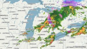
Last night’s storms totally missed us, but we have another chance to see some later today. Radar is showing that most will be tame in our area, but we never know. Once again the heavy storms are rolling through the middle portions of the lower peninsula so a narrow band may affect us. Highs today reached into the 70s but will be falling once this last batch of storms moves through.
Our 5 PM temperature is 68°F, the humidity is 66%, and skies are overcast. Winds are from the WSW at 11-17 mph and the pressure is 29.69 in and rising. The dew point is 56°F and visibility is 11 miles. Yesterday’s high was 74°F and the overnight low was 56°F. Record temps for March 30 are 74°F (yesterday) and 15°F (2022). Sunrise was at 6:52 AM and sunset will be at 8:01 PM.
DURAND / OWOSSO FORECAST:
Tonight: A chance of showers and thunderstorms. Lows falling to the mid 30s. Some storms could be severe. Winds NNW at 10-20 mph. Chance of rain 70%.
Wednesday: Cloudy with showers early. Highs in the low 40s. Winds NE at 10-15 mph.
Wednesday Night: Cloudy with showers overnight. Lows near 32°F. Winds ENE at 10-15 mph. Chance of rain 60%.