A Mix Of Rain And Sun . . . .
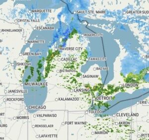
Today is one of those days that Mother Nature isn’t sure what she wants to do. Our morning was overcast, but now it’s an even mix of sun and clouds. Every so often we get some sprinkles of rain thrown into the mix. The area is still recovering from all the rain that we got, and a flood warning remains in effect for our county. Right now the sun is out and temperatures are a little below the average. It’s going to be this way most of the week, then Thursday we may see warmer temps.
Our 3 PM temperature is 45°F, the humidity is 60%, and skies are partly cloudy. Winds are from the west at 4-9 mph, and the pressure is 3.0 in and steady. The dew point is 31°F and visibility is 8 miles. Yesterday’s high was 42°F and the overnight low was 33°F. Average temps for this date are 53°F/31°F. Record temps for April 5 are 79°F (2021) and 13°F (2016). Sunrise was at 7:10 PM and sunset will be at 8:08 PM.
DURAND / OWOSSO FORECAST:
This Afternoon: Partly cloudy with a chance for showers or thunderstorms. Highs in the mid 40s. Winds WNW at 15-25 mph. Chance of rain 40%.
Tonight: Partly cloudy. Lows in the lower 20s. A chance of rain or snow showers. Winds NW at 10-20 mph.
Tuesday: Partly cloudy with a chance of snow flurries early. Highs in the upper 30s. Winds N at 5-10 mph.