Record Warmth For The Week Ahead . . . .
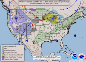
This upcoming week will feel like late May or early June. Highs will reach into the 70s everyday and I’m expecting many records will be broke or tied. With that comes the possibilities of severe weather, mostly on Wednesday along with more heavy rain. The city of Cheboygan is on alert for their dam failing, and there are concerns for other dams in the state. Today is very pleasant although on the windy side. We had cloudy skies this morning, but now we have a mix of sun and clouds.
Our 4:15 PM temperature is 76°F, the humidity is 50%, and winds are from the SW at 4-12 mph, and the pressure is 29.83 in and rising. The dew point is 55°F and visibility is 12 miles. Yesterday’s high was 80°F and the overnight low 22°F. Record temps for April 12 are 80°F (yesterday) and 22°F (2016). Sunrise was at 6:58 AM and sunset will be at 8:16 PM.
DURAND / OWOSSO FORECAST:
Tonight: Becoming mostly cloudy and warm. Possible heavy thunderstorms with damaging winds. Low in the lower 60s. Winds SSW at 10-20 mph. Chance of rain 70%.
Tuesday: Showers and thunderstorms early. Cloudy skies and very warm. Highs in the upper 70s. Winds WSW at 15-20 mph. Chance of rain 60%.
Tuesday Night: Possible scattered thunderstorms in the evening, then more widespread overnight. Some could be severe. Chance of rain 90%. Winds SSW at 10-20 mph.