A Very Stormy Afternoon . . . .
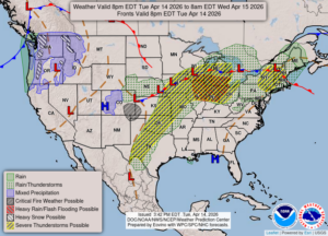
Although my area hasn’t had any storms yet, northern Michigan, and some areas in mid Michigan, are battling the flooding situation. As the weather map shows, there is a large area in the severe area for today, although we’re expecting ours overnight. The storms affecting Iowa, Wisconsin, Illinois, and Indiana will be heading our way overnight. Ryan Hall is covering it on YouTube, and I’m sure the Michigan Weather Chasers will also be very soon. Right now, we have sun which will be fueling the storms, so we’ll have to prepare for some possibly some nasty weather later.
Our 4:45 PM temperature is 74°F, the humidity is 56%, and skies are mostly cloudy. Winds are from the WSW at 0-4 mph, and the pressure is 29.74 in and rising. The dew point is 54°F and visibility is 13 miles. Yesterday’s high was 77°F and the overnight low was 63°F. Average temps for this date are 56F/34F. Record high for April 13 is 79°F (2023) and 25° F (2025). Sunrise was at 6:57 AM and sunset will be at 8:17 pm.
DURAND / OWOSSO FORECAST:
Tonight: Thunderstorms, possibly severe. Overcast and continued warm. Destructive winds and flash flooding are possible. Lows in the low 60s.
Wednesday: Scattered thunderstorms, mainly in the afternoon. Highs near 70F. Winds SW at 10-15 mph. Chance of rain 60%.
Wednesday Night: Showers and thunderstorms. Highs in the lower 60s.