Storm System Finally Ending . . . .
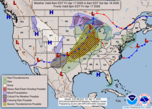
The severe storm system which has affected us the past four days is finally ending after today. They will still be firing to our west, but our storm chances are very slight. We could still see a thunderstorm overnight, but nothing severe is expected.
Our 1:45 PM temperature is 71°F, the humidity is 67%, and skies are partly cloudy. Winds are from the SSE at 0-7 mph and the pressure is 29.90 in and falling. The dew point is 54°F and visibility is 10 miles. Yesterday’s high was 65°F and the overnight low was 46°F. Average temps for this date are 58°F/35°F. Record temps for April 16 are 77°F (2016) and 24°F (2014). Sunrise was at 6:52AM and sunset will be at 8:21 PM.
DURAND / OWOSSO FORECAST:
Today: Partly cloudy. Highs in the low 70s. Winds SSE at 10-20 mph.
Tonight: Increasing clouds with thunderstorms likely. Lows in the lower 50s. Chance of rain 80%.
Saturday: Showers and a possible thunderstorm early. Remaining cloudy in the afternoon with highs in the mid 60s, falling to near 50°F late. Winds WSW at 10-20 mph. Chance of rain 60%.