Storms Over, Significant Cool Down . . . .
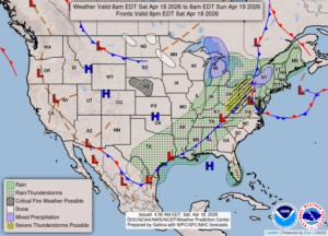
Our weather has calmed down and the storm system that was over us has moved on the the east. Today is wet, but most of the rain has moved east. Radar is showing no rain to our west although overcast skies remain.
Our 3:30 PM temperature is 49°F, the humidity is 73%, and winds are from the west at 7-11 mph, and the pressure is 29.70 in and rising. The dew point is 39°F and visibility is 10 miles. Yesterday’s high was 76°F and the overnight low was 59°F. Average temps for this date are 58°F/20°F. Sunrise was at 6:50 AM and sunset will be at 8:22 PM.
DURAND / OWOSSO FORECAST:
This Afternoon: Overcast skies with a shower possible. Highs in the upper 40s. Winds west at 15-25 mph.
Tonight: Becoming partly cloudy. Lows in the lower 30s with a freeze advisory in effect. Winds west at 15-20 mph.
Sunday: Partly sunny early, then cloudy in the afternoon with a chance of showers. Highs in the mid 40s. Winds WSW at 10-20 mph. Chance of rain 30%.