
A Strange Weather System . . . .
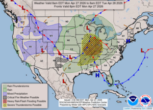
As the weather map shows, the severe weather is not expected to reach as far north as us, but we could get high winds comparable to a severe thunderstorm tonight. Gusts up to 70 mph will not be uncommon. We could see rain but the wind is expected to happen after the storms have passed. This will truly be a strange scenario.
Our 1:30 PM temperature is 70°F, the humidity is 38%, and skies have a light cloudy cover with hazy sun. Winds are from the east at 9-12 mph, and the pressure is 29.86 in and falling. The dew point is 37°F and visibility is 12 miles. Yesterday’s high was 71°F and the overnight low was 43°F. Average temps for this date are 62°F/39°F. Record temps for April 26 are 80°F (2016) and 26°F (2015). Sunrise was at 6:36 AM and sunset will be at 8:32 PM.
DURAND / OWOSSO FORECAST:
This Afternoon: Mostly cloudy. Highs in the lower 70s. Increasing winds at 15-25 mph gusting higher at times.
Tonight: Becoming very windy and cloudy with showers and thunderstorms likely. Lows in the mid 50s. Winds SSE at 20-30 mph, gusting higher at times. Chance of rain 80%.
Tuesday: Mostly cloudy with a chance of showers early. Temps steady in the low 60s. Winds west at 15-25 mph. Chance of rain 30%.