Continued Below Average Temperatures . . . .
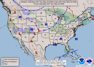
Spring seems to be having trouble holding on this year. We should be seeing highs in the low 60s now, and some days have a difficult time reaching 50°F. Tomorrow is expected to possibly reach 70°F, and then I’m hearing that there is a slight chance for more severe weather. That indicates more cold temperatures coming.
Our 1:00 PM temperature is 60F, the humidity is 32%, and winds are from the WSW at 14-16 mph. The pressure is 29.74 in and falling. The dew point is 27F and visibility is 15 miles. Skies are mostly cloudy. Yesterday’s high was 51°F and the overnight low was 37F. Average temps for this date are 64°F/41°F. Record temps for May 2 are 84°F (2018) and 32°F (yesterday). Sunrise was at 6:28 AM and sunset will be at 8:39 PM.
DURAND / OWOSSO FORECAST:
Today: Mostly cloudy with some breaks of the sun. A slight chance of a few showers. Highs in the low to mid 60s. Winds WSW at 20-30 mph. Chance of rain 20%.
Tonight: Mostly cloudy with a slight chance of showers. Gradual overnight clearing with lows in the mid 40s. Winds SW at 10-20 mph with higher gusts possible. Chance of rain 20%.
Monday: Mostly sunny. Highs in the mid 70s. Winds SW at 15-25 mph. A slight chance of a rain shower.