
Unseasonably hot weather . . . .
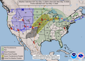
According to the NOAA weather map, we are in the area for possible severe weather, although locals are saying the chances are very small. In fact, this threat will exist for the next three days. Michigan Weather Chasers are predicting that Tuesday will have the highest threat. Today began with warm temperatures and clear skies. Now more clouds have moved in. We can expect thunderstorms later today.
Our 1 PM temperature is 83°F, the humidity is 49%, and winds are from the SE at 2-4 mph and the pressure is 30.15 in and falling. The dew point is 60F and visibility is 12 miles. Yesterday’s high was 82°F and the overnight low was 57°F. Average temps for this date are 70°F/47°F. Record temps for May 16 are 84°F (2007) and 31°F (2016). Sunrise was at 6:12 AM and sunset will be at 8:55 PM.
DURAND / OWOSSO FORECAST:
This Afternoon: Increasing clouds with highs in the lower 80s. A stray shower or thunderstorm is possible. Winds south at 5-10 mph. Chance of rain 30%.
Tonight: Cloudy skies with scattered thunderstorms possible early. Then gradually becoming mostly clear overnight. Lows in the mid 60s. Winds SE at 5-10 mph. Chance of rain 30%.
Monday: Increasing clouds with showers and thunderstorms. Chance of rain 60%. Winds SSW at 15-25 mph.