Much Cooler After The Storms . . . .
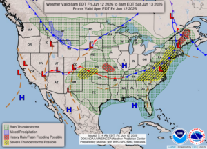
Yesterday evening brought the threat of severe storms and tornadoes. We did have a thunderstorm but nothing close to severe. There were several tornado warnings issued but I haven’t heard of any touching down or damage so far. We were under a tornado watch most of the evening but we were lucky once again. Today has more comfortable temperatures.
Our 4 PM temperature is 75°F, the humidity is 46%, and winds are from the WSW at 3-14 mph. Skies are mostly clear and the pressure is 29.77 and rising. The dew point is 47°F, and visibility is 13 miles. Yesterday’s high was 86°F and the overnight low was 61°F. Average temps for June 12 is 78°F/56°F. Record temps for June 11 are 93°F (2005) and 41°F (2006). Sunrise was at 5:58 AM and sunset will be at 9;16 PM.
DURAND / OWOSSO FORECAST:
This Afternoon: Mostly clear. Highs in the upper 70s. Winds WSW at 15-25 mph.
Tonight: Clear with lows in the upper 50s. Winds WSW at 10-20 mph, decreasing late.
Saturday: Mostly sunny with highs in the mid 80s. Winds WSW at 10-20 mph.