Partly Rainy Sunday . . . .
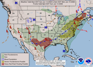 We were spared from the severe weather that affected neighbors to our south, who were once again victims of tornadoes and strong storms. It seems to be a weekly occurrence for these states. This morning began with rain, but now we have mostly cloudy skies with a peek of the sun once and awhile. The radar looks like most of it is now to our east. More is expected to develop this afternoon. At least the hot, humid weather is gone.
Our 4 PM temperature is 65°F, the humidity is 70%, and skies are mostly cloudy. Winds are from the NW at 2-11 mph, and the pressure is 29.65 in and steady. The dew point is 54°F and visibility is 10 miles. Yesterday’s high was 83°F and the overnight low was 53°F. Average temps for this date are 78°F/56°F. Record temps for June 13 are 92°F (2017) and 44°F (2016). Sunrise was at 5:57 AM and sunset will be at 9:17 PM.]
DURAND / OWOSSO FORECAST:
This Afternoon: Mostly cloudy with a chance of showers. Steady temps in the mid 60s. Winds NW at 10-20 mph. Chance of rain 30%.
Tonight: Partly to mostly cloudy. Lows in the mid 40s. Winds NW at 5-15 mph.
Monday: Partly cloudy. Highs in the mid 70s. Winds W at 5-15 mph.