
Storms Developing Tonight . . . .
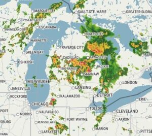
After a quiet morning, storms are now moving through lower Michigan. So far, all we have had are light sprinkles but radar is showing much more coming our way. Most has remained north of us but we have had some close thunder. There is the slight chance that some of these storms could be severe, and there has been some warnings issued but no reports of any damage at this time.
Our 7 PM temperature is 63°F, the humidity is 75%, and winds are SW at 0-6 mph., and the pressure is 29.52 in and falling. The dew point is 36°F and visibility is 11 miles. Yesterday’s high was 72°F and the overnight low was 46°F. Average temps for this date are 79°F/57°F. Sunrise was at 5:37 AM and sunset will be at 9:18 PM.
DURAND / OWOSSO FORECAST:
Tonight: Mostly cloudy with showers and thunderstorms before midnight. Some could be severe. Low temps in the lower 50s. Winds from the south at 5-15 mph. Chance of rain 100%.
Wednesday: Partly to mostly cloudy early, then rain developing in the afternoon. Highs in the low 70s. Winds SW at 10-15 mph. Chance of rain 70%.
Wednesday Night: Showers and thunderstorms overnight. Some rain could be heavy. Winds SSW at 10-20 mph. Chance of rain 80%.