Cloudy With Snow Flurries . . . . .
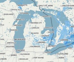
We have cool temperatures but actually, close to normal for this date. Those few very warm days spoiled us but we do have more coming by week’s end. Right now, the sun is trying to peek out, and we have been having intermittent snow flurries most of the morning. It won’t be very warm today, but Wednesday and Thursday look to be our pick days of the week.
Our 1:15 PM temperature is 35°F, the humidity is 55%, and winds are from the NW at 2-8 mph. The pressure is 30.27 in and rising. The dew point is 22°F and visibility is 10 miles. Yesterday’s high was 49°F and the overnight low was 32°F. Average temps for this date are 47°F/26°F. Record temps for March 22 are 86°F (2012) and 9°F (2004). Sunrise was at 7:35 AM and sunset will be at 7:52 PM.
DURAND / OWOSSO FORECAST:
This Afternoon: Mostly cloudy with snow showers. Highs in the mid 30s. Winds NNW at 10-20 mph, and the chance of snow is 40%.
Tonight: Partly cloudy with a few snow showers possible. Lows the in lower 20s. Winds NNW at 5-20 mph.
Tuesday: Partly cloudy early, then increasing clouds in the afternoon. Highs in the upper 40s. Winds SW at 10-15 mph, gusting higher at times.