A Little Rain Coming Soon . . . .
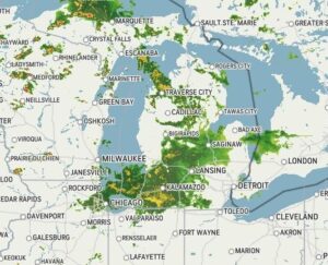
Our morning began with sun, but now clouds are taking over. Radar is showing rain on the way and it is expected to last through the night. Temperatures are still a bit below where they should be, but the heat will return this weekend.
Our 2:45 PM temperature is 72°F, the humidity is 59% and skies are cloudy. Winds are from the SW at 2-7 mph, and the pressure is 30.00 in and steady. The dew point is 57°F and visibility is 21 miles. Yesterday’s high was 79°F and the overnight low was 56°F. Average temps for this date are 81°F/58°F. Record temps for June 23 are 93°F (2025) and 47°F (2021). Sunrise was at 5:59 AM and sunset will be at 9:19 PM.
DURAND / OWOSSO FORECAST:
This Afternoon: A chance of showers and a thunderstorm late this afternoon. Highs in the lower 70s. Winds WSW at 5-10 mph and chance of rain is 60%.
Tonight: Showers and a chance for a thunderstorm. Lows in the upper 50s. Winds light and variable. Chance of rain 80%.
Thursday: Showers and thunderstorms. Winds WSW at 5-10 mph. Chance of rain 50%.