Another Day Of Possible Severe Storms . . . . .
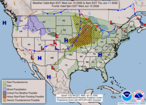
We have a chance for severe weather today and tomorrow. Yesterday brought a few localized strong storms and two tornadoes. Thankfully, they were weak and didn’t do much damage. They were about 20-30 miles north of us. Our Michigan Storm Chasers are on high alert, both today and tomorrow. They do a great job and sometimes get the warnings out before NOAA. Right now we have partly to mostly cloudy skies and no sign of storms at this time. Even the radar is clear.
Our 2 PM temperature is 84F, the humidity is 63% and winds ar from the WSW at 0-7 mph. The pressure is 29.70 in and falling. The dew point is 70F and visibility is 12 miles. Yesterday’s high was 83F and the overnight low was 62F. Average temps for this date are 77F/55F. Record temps for June 9 are 95F (2011) and 41F (2016). Sunrise was at 5:58 AM and sunset will be at 9:15 PM.
DURAND / OWOSSO FORECAST:
This Afternoon: Showers and thunderstorms likely late. Locally heavy downpours possible. Highs in the lower 90s. Winds SW at 10-15 mph. Chance of rain 100%
Tonight: Showers and thunderstorms overnight. Some could be heavy or severe. Lows near 70F. Winds SW at 5-20 mph. Rain chances 80%.
Thursday: Partly to mostly cloudy. Highs near 90F. Winds WSW at 10-15 mph.