More Storms, Possibly Severe . . . .
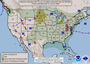
Yesterday was a relief from the very hot weather, but it has returned today. Popup showers and thunderstorms were around most of the day, but we didn’t get one until late last night. It looks like today will bring more of the same. Temperatures, humidity, and dew points are ripe for severe weather, but right now, skies are partly cloudy and it is breezy. We did get just under quarter of an inch of rain last night, and I’m sure that makes the farmers happy.
Our 1:30 PM temperature is 88°F, the humidity is 65% and the pressure is 29.86 in and falling. Winds are from the SW at 9-11 mph. The dew point is 73°F and visibility is 10 miles. Yesterday’s high was 86°F and the overnight low was 69°F. Average temps for this date are 81°F/58°F. Record highs for June 26 are 99°F (1921) and 43°F (1981). Sunrise was at 5:59 AM and sunset will be at 9:20 PM.
DURAND / OWOSSO FORECAST:
This Afternoon: Partly cloudy with a chance of thunderstorms. Some could be severe. High 89°F. Winds SW at 10-20 mph. Chance of rain 70%
Tonight: Cloudy early, becoming partly cloudy after midnight. A chance of showers and thunderstorms early. Winds WSW at 10-15 mph. Chance of rain 30%.
Saturday: Mostly sunny. High in the low 80s. Winds WNW at 5-10 mph.