Fog To Start The Day, Now Some Sun . . . .
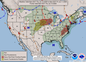
After strong thunderstorms and a lot of rain yesterday, today started out damp but now is drying out some. We had dense fog early which was gone by noon. Now we have clouds with a few peeks of the sun. There is no more rain in the forecast until tomorrow, and it looks like we could have more strong storms for our weekend. This is supposed to be the dry season for us. I wish it would happen.
Our 1:15 PM temperature is 77°F, the humidity is 73%, and skies are cloudy. Winds are from the NW at 3-7 mph, and the pressure is 29.94 in and rising. The dew point is 68°F and visibility is 15 miles. Yesterday’s high was 83°F and the overnight low was 67F. Average temps for this date are 82°F/60°F. Record temps for July 9 are 105°F (1936) and 42°F (1963). Sunrise was aat 6:07 AM and sunset will be at 9:16 PM.
DURAND / OWOSSO FORECAST:
Today: Becoming mostly sunny. High 82°F. Winds WNW at 5-10 mph.
Tonight: Partly cloudy. Low in the mid 60s. Winds light and variable.
Friday: Becoming mostly cloudy. A stray shower or thunderstorm is possible in the afternoon. High 83°F. Winds S at 5-10 mph. Chance of rain 40%.