Too Hot For Me . . . .
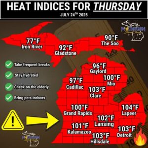
We will see temperatures in the 90s today, with the heat index over 100F This is not my kind of weather. It was very warm overnight and my AC ran all night which it usually doesn’t do. We could see some thunderstorms later today and overnight. Those would be welcome if it would cool down a little.
Our 12:15 PM temperature is 90°F, the humidity is 60%, and winds are from the SW at 5-12 mph. Skies are mostly clear. The pressure is 29.93 in and falling. The dew point is 73°F and the heat index is very high at 8 (99°F). Yesterday’s high was 89°F and the overnight low was 75°F. Average temps for this date are 82°F/60°F. Record temps for July 23 are 100°F (1933) and 44°F (1985). Sunrise as at 6:20 AM and sunset will be at 9:06 PM.
DURAND / OWOSSO FORECAST:
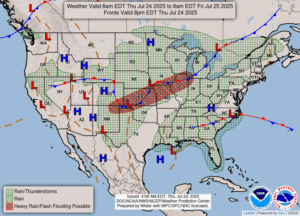
Today: Increasing clouds with a chance of showers and thunderstorms. Hot with a highs in the mid 90s. Winds W at 5-10 mph. Chance of rain 60%.
Tonight: Scattered thunderstorms. Low 71°F. Winds light and variable. Chance of rain 50%.
Friday: A little cooler. Cloudy with decreasing clouds in the afternoon. A 30% chance of showers Winds light and variable. Highs in the mid 80s.