Another Air Quality Alert Day. . . . . .
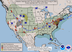
Once again, we are affected by the Canadian wildfires, and we have a lot of smoke in the air. The sky is a mix of clouds and smoke and it’s hard to distinguish between the two. Yesterday was bad also, but then the rains came and cleared the air a little. Rain began in the late afternoon, and continued most of the night. We got 0.29 in. Detroit has been plagued by flooding and they received another 1-2 inches yesterday. Even Metro Airport was flooded and flights had to be cancelled. This has not been a nice summer. There has been too much 90 degree weather, then when it cools down, it rains.
Our 12:15 PM temperature is 71°F, the humidity is 69%, and skies are partly cloudy. Winds are from the NE at 2-7 mph, and the pressure is 30.05 in and rising. The dew point is 57°F and visibility is 7 miles. Yesterday’s high was 83°F and the overnight low was 67°F. Record temps for July 30 are 98F (1933) and 44°F (1965). Sunrise was 6:27 AM and sunset will be at 8:59 PM.
DURAND / OWOSSO FORECAST:
Today: Widespread haze and mostly sunny. Highs in the mid 70s. Winds SE at 10-15 mph.
Tonight: Partly cloudy. Lows in the lower 50s. Winds NNE at 10-15 mph
Friday: Mostly sunny. Highs in the mid to upper 70s. Winds NE at 5-10 mph.