A Rainy Day . . . .
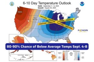
After a very warm, wet summer, our autumn season is beginning just the opposite. My area is looking at below average temperature for the next week or so. For those of us who hate hot weather, this isn’t a bad thing. I’m just hoping that we don’t see more rain than what we have had. Today began with sun, but now we have rain, and it is expected to last most of the day and overnight. We could even have some thunder thrown in for good measure.
Our 4:15 PM temperature is 65°F, the humidity is 90% and skies are overcast with light rain. Winds are from the SW at 2-7 mph. The pressure is 29.37 in and steady. The dew point is 59°F and visibility is 9 miles. Yesterday’s high was 79°F and the overnight low was 53°F. Average temps for this date are 77°F/55°F. Record temps for Sept 2 are 91°F (2011) and 41°F (2017). Sunrise was at 7:04 AM and sunset will be at 8:09 PM.
DURAND / OWOSSO FORECAST:
This Afternoon: Cloudy with showers. A thunderstorm is possible. Highs in the upper 70s. Winds from the SW at 10-20 mph and chance for rain is 100%.
Tonight: Occasional showers with thunder possible. Winds WSW at 5-10 mph, gusting higher at times. Lows in the upper 40s. Chance of rain 100%.
Thursday: Chance of morning showers, then becoming mostly sunny. Highs in the mid 60s. Wind W at 10-20 mph. Chance of rain 30%.