More Rain Expected . . . .
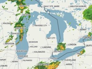
We had very little rain yesterday, only 0.09″. That’s fine because we have received more than our share this summer. Some drought stricken areas finally got some, but could use much more. We have rain in the forecast for much of this week, so hopefully, it will go to those areas that need it.
Our 1:30 PM temperature is 73°F, the humidity is 79%, and skies are overcast. Winds are from the SW at 3-5 mph, and the pressure is 29.95 in and steady. The dew point is 65°F and visibility is 11 miles. Yesterday’s high was 73°F and the overnight low was 60°F. Average temps for this date are 71°F/49°F. Record temps for Sept 21 are 85°F (2019) and 34°F (2020). Sunrise was at 7:24 AM and sunset will be at 7:35 PM.
DURAND / OWOSSO FORECAST:
This Afternoon; Cloudy with a chance of showers and thunderstorms. Highs in the upper 70s. Winds SW at 5-10 mph. Chance of rain 30%.
Tonight: Mostly cloudy. A 40% chance of a shower or thunderstorms. Low around 60°F. Winds light and variable.
Tuesday: Mostly cloudy. Scattered showers and thunderstorms possible in the afternoon. Winds S at 0-5 mph. Highs in the upper 70s. Chance of rain 50%.