Another Record Breaker . . . .
We broke another high temp record yesterday, but we will see the weather turning the corner for more normal temperatures on Tuesday. It was nice while it lasted. Rain is expected to usher in the cooler weather and we could see some thunderstorms. Hopefully, none will be damaging.
Our 1:45 PM temperature is 82°F, the humidity is 48%, and winds are from the SW at 5-13 mph, and the pressure is 29.99 in and falling. The dew point is 59°F and visibility is 11 miles. Yesterday’s high was 88°F and the overnight low was 63°F. Average temps for this date are 65°F/45°F. Record temps for Oct. 5 are 88°F (yesterday) and 26°F (2004). Sunrise was at 7:40 AM and sunset will be at 7:10 PM.
DURAND / OWOSSO FORECAST:
Today: Increasing clouds with a slight chance of a shower. Highs in the mid 80s. Winds SW at 10-20 mph, gusting high at times. Chance of rain 10%.
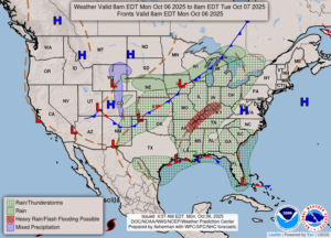
Tonight: Showers and thunderstorms likely. Lows in the upper 50s. Winds SW at 5-10 mph. Chance of rain 100%
Tuesday: Cloudy with periods of rain. Highs in the lower 60s. Winds N at 5-10 mph. Chance of rain 70%.