Not A Bad Day . . . . .
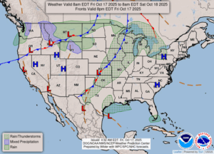
Today will be a typical autumn day although the temperatures will be a bit warmer than normal. We had a little rain overnight which left 0.04″ in my gauge. This weekend could be a bit on the stormy side and we really do need the rain. The remainder of this month is still expected to remain warmer than normal.
Our 1 PM temperature is 66°F, the humidity is 47%, and winds are from the SSW at 2-8 mph. Skies are mostly cloudy and the dew point is 41°F. The pressure is 29.77 in and falling and visibility is 13 miles. Yesterday’s high was 64°F and the overnight low was 42°F. Average temps for this date are 59°F/42°F. Record temps for Oct. 16 are 71°F (2016) and 29°F (2020). Sunrise was at 7:53 AM and sunset will be at 6:51 PM.
DURAND / OWOSSO FORECAST:
This Afternoon: Mostly cloudy with highs in the upper 60°F. There is a 20% chance of a shower. Winds S at 10-20 mph.
Tonight: Mostly cloudy. Slight chance of a shower. Lows in the mid 50s. Winds S at 10-15 mph.
Saturday: Partly cloudy early, then showers and a possible thunderstorm developing later in the day. Highs in the low 70s. Winds SSW at 10-15 mph and chance of rain 80%,