Feels Like A Spring Day . . . .
We better enjoy the next few days because this warm weather is not going to last. The past two days brought fog, which was very dense on Tuesday. Visibility was about a mile or less most of the day. Today brought a mix of sun and clouds and temperatures about 20 degrees above average. There is very little snow left, just in time to get more early next week.
Our 2:45 PM temperature is 53°F, the humidity is 57%, and winds are from the south at 3-12 mph. Skies are mostly cloudy and the pressure is 29.79 in and falling. The dew point is 34°F and visibility is 11 miles. Yesterday’s high was 40°F and the overnight low was 34°F. Average temps for this date are 31°F / 20°F. Record temps for Jan. 7 are 56°F (2008) and -17°F (2018). Sunrise was at 8:07 AM and sunset will be at 5:19 PM.
DURAND / OWOSSO FORECAST:
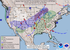
This Afternoon: Partly sunny. Highs in the mid 50s., Winds SSE at 15-20 mph Rain developing late with rain chances at 100%.
Tonight: Periods of rain with increasing winds. Temps remaining in the 50s overnight. Winds SSE at 20-30 mph. Chance of rain 100%.
Friday: Rain early with falling temperatures, Highs in the upper 50s in the morning. Cloudy, windy and colder in the afternoon. Chance of rain 80%.