
Possibly The End To Our Summer Weather In Mid Michigan
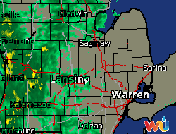
The past two days were very warm and dry, but today will see the end of it. Our temperatures are still in the 70s but they will be dropping the remainder of the day after another cold front goes through. We are starting to get a few sprinkles but the heavy rain is showing on radar and heading our way. This is expected to continue through tonight. Tomorrow will be dryer but about 20°F colder . I’m sitting here watching the hurricane coverage on the Weather Channel, and just happy that I’m not down there.
Our 2:15 PM temperature is 75F (24°C), the humidity is 63%, and skies are overcast. Winds are from the south at 14 mph, gusting to 18 mph. The heat index is 79°F (26°C) and the pressure is 29.76 in (1007.8 mb) and falling. Yesterday’s high was 86°F (29°C) and the overnight low was 67°F (19°C). The averages for this date are 62°F / 44°F. The record high for Oct. 9 is 88°F set in 2007, and the record low is 24°F set in 1989.
DURAND / OWOSSO FORECAST:
Today: Showers and possible thunderstorms. High 78°F. Winds S at 10mph, gusting to 21 mph. Chance of rain 80%.
Tonight: Showers and a possible thunderstorm. Low 52°F. Winds SSE at 11-15 mph. Chance of rain 90%.
Thursday: Partly sunny. High 54°F. Winds W 15-20 mph, gusting to 33 mph.
Thursday Night: Mostly cloudy. Low 37°F. Wind W 10-15 mph, gusting to 25 mph.