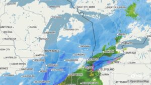
Winter Storm Arrived On Schedule – Mid Michigan
The rain began late yesterday afternoon and continued into the overnight. I’m not sure when it changed over to snow but there was 3.5 inches already on my deck when I got up shortly after 8AM. A steady, moderate snow has continue since then and I think that we have another inch or two in accumulation since then. This is expected to continue until sometime tomorrow morning. We did our shopping yesterday so our grocery situation is in good shape. The temperature yesterday reached close to 50°F and with the sun out most of the day, we lost much of our existing snow pack. That’s good considering how much we may get today.
Our 10:45 AM temperature is 31°F (-1°C), the humidity is 97%, and skies are cloudy with snow. Winds are from the NNW at 0-5 mph and the dew point is 29°F (-2°C). The pressure is 29.98 in (1015.2 mb) and rising, and visibility is 1 mile. Yesterday’s high was 47°F (8°C) and the overnight low was 30°F (-1°C). Average temps for this date are 28°F / 14°F. Sunrise was at 7:50 AM and sunset will be at 5:50 PM.
DURAND / OWOSSO FORECAST: