Cloudy With A Threat Of Rain – Mid Michigan
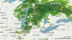
Rain is in our forecast for today, and radar is showing it slowly approaching us. At this time, however, it appears to be light with no significant storms developing. Thunderstorms are supposed to develop this afternoon but that remains to be seen. I was hoping that we’d get some rain since I haven’t watered my garden in a few days, and it is getting pretty dry. The northern portions of the state seem to be getting a good drenching, if you can tell by the radar. But it doesn’t appear to be heavy.
Our 12 noon temperature is 72°F, the humidity is 70%, and winds are from the SSW at 1-5 mph. Skies are overcast and he dew point is 61°F. The pressure is 29.77 in and steady, and visibility is 12 miles. Sunrise was at 5:58 AM and sunset will be at 9:12 PM. Yesterday’s high was 65°F and the overnight low was 59°F. Average temps for this date are 73°F / 53°F.
DURAND / OWOSSO FORECAST: