A Lovely August Day . . . . .
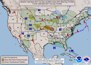
Today has been beautiful but we could see some heavy weather later today. Thunderstorms are in the forecast and some reaching severe are not out of the question. We’ve been very lucky so far this year, and prayers go out for the folks battling those horrific floods in the states to our south. I wish that these heavy rains would go to where the wildfires are.
Our 5:15 PM temperature is 79°F, the humidity is 54% and skies are partly cloudy. Winds are from the SW at 2-9 mph, and the pressure is 29.95 in and falling. The dew point is 61°F and visibility is 11 miles. Yesterdays high was 80°F and the overnight low was 57F. Average temps for this date are 80°F/59°F. Record temps for August 17 are 90°F (2009) and 50°F (2013). Sunrise was at 6:46 AM and sunset will be at 8:35 PM.
DURAND / OWOSSO FORECAST:
Tonight: Showers and thunderstorms likely. Heavy rain , gusty winds and hail are possible. Winds WSW at 10-15 mph. Lows in the low 60s. Chance of rain 80%.
Wednesday: Cloudy with a chance of rain early. Gradual clearing later in the day. High near 80°F. Winds light from the NNW. Chance of rain 30%.
Wednesday Night: Mostly clear. Lows in the mid 50s. Winds light and variable.