Hot And Humid . . . . .
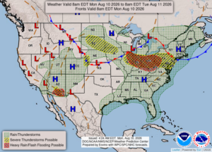
Yesterday began with sun and ended with some state-wide severe weather. We had a few showers and a little thunder, but nothing severe. As of late last night, many on the west side of the state were without power, and severe thunderstorm warnings were in effect until the wee hours of the morning. We could see a repeat tonight.
Our 12:30 PM temperature is 78°F, the humidity is 67%, and skies are mostly clear although I think there is smoke in the air because the sky seems quite hazy. Winds are from the south at 5-6 mph, and the pressure is 30.03 in and steady. The dew point is 67°F and visibility is 10 miles. The Air Quality Index is moderate at 60. Yesterdays high was 85°F and the overnight low was 65°F. Average temps for this date are 81°F/59°F. Record temps for August 9 are 91°F (2007) and 52°F (2016). Sunrise was at 6:37 AM and sunset will be at 8:47 PM.
DURAND / OWOSSO FORECAST:
Today: Mostly sunny with areas of smoke. Highs in the mid 80s. Winds from the west at 5-10 mph
Tonight: Becoming mostly cloudy. Showers and thunderstorms possible. Lows in the lower 60s. Winds NW at 5-10 mph.
Tuesday: A mix of sun and clouds. Highs in the low 80s. Increasing clouds in the afternoon with a shower or thunderstorm possible. Winds mostly calm. Chance of rain 30%.