Storms On The Way . . . .
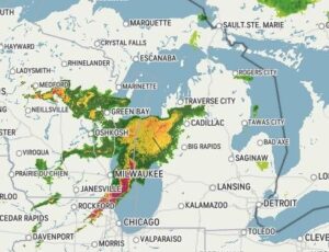
The severe thunderstorm watch area hasn’t quite reach us as yet, but I’m expecting it any time. Fox weather radar is showing it to hit us about 6 or 7 PM. I find the Fox radar to be most accurate when it comes to timing these storms. Right now, we have hazy sun but the clouds are becoming more dense. Temperatures are expected to reach the mid 80s by the time the storms reach us, and I’m not seeing much of a cool-down after. Welcome to the dog days of summer.
Our 2 PM temperature is 81°F, the humidity is 47%, and winds are from the SW at 1-9 mph and the pressure is 30.13 in and falling. The dew point is 57F and visibility is 11 miles. Yesterdays high was 83°F and the overnight low was 57F. Average temps for this date are 81°F/59°F. Record temps for August 8 are 89°F (2012) and 50°F (2017). Sunrise was at 6:36 AM and sunset will be at 8:48 PM.
DURAND / OWOSSO FORECAST:
This Afternoon: Increasing clouds with thunderstorms possible Highs in the mid 80s. Winds WSW at 5-15 mph Chance of rain 60%.
Tonight: Showers and thunderstorms. Some storms could be strong to severe. Lows in the mid 60s. Winds SSW at 5-10 mph. Chance of rain 100%.
Monday: Mostly cloudy with a chance of showers early, Becoming partly sunny with highs in the lower 80s. Chance of rain 30%.