Continued Storms . . . .
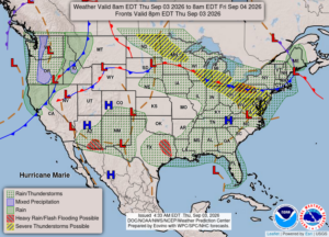
Storms began late yesterday and continued overnight. The severe storms remained to our north and south, but we did get little over half and inch of rain by this morning. We now have more storms forming over the state but there have been no weather warnings for our area. A tornado warning has just been issued for Gratiot county which is to our northwest.
Our 2 PM temperature is 80°F, the humidity is 84%, and skies are overcast. Winds are from the SE at 0-4 mph, and the pressure is 29.92 in and rising. The dew point is 72°F and visibility is 10 miles. Yesterday’s high was 92°F and the overnight low was 70°F. Average temps for this date are 78°F/55°F. Sunrise was at 7:04 AM and sunset will be at 8:09 PM.
DURAND / OWOSSO FORECAST:
Today: Severe thunderstorm watch until 7 PM. Mostly cloudy with possibly strong thunderstorms. Winds light and variable. Chance of rain 50%.
Tonight: Showers and thunderstorms likely. Some may be strong with gusty winds. Lows in the upper 60s. Winds light and variable. Chance of rain 60%.
Friday: Scattered thunderstorms in the morning. Cloudy in the afternoon. Storms could be strong with gusty winds. Highs in the upper 70s. Chance of rain 70%.