
Finally Cooling Down . . . .
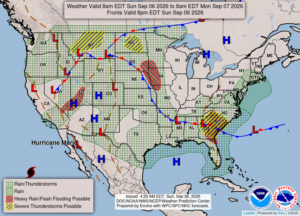
The state is recovering from severe weather on Thursday. Many are still without power, and the Detroit area is cleaning up from two tornadoes and 70 mph straight line winds. The straight line winds did as much damage as the tornadoes. Today is feeling much more comfortable after high humidity and dew points from earlier in the week. We’re hoping that the hot weather is over for the season.
Our 1:15 PM temperature is 74°F, the humidity is 59%, and winds are from the north at 3-7 mph. Skies are partly cloudy and the pressure is 30.05 in and steady. The dew point is 55°F and visibility is 10 miles. Yesterday’s high was 79°F and the overnight low was 54°F. Average temps for this date are 77°F/54°F. Sunrise was at 7:07 AM and sunset will be at 8:04 PM.
DURAND / OWOSSO FORECAST:
Today: Partly cloudy. Highs in the upper 70s. Winds NE at 10-15 mph.
Tonight: Mostly clear with lows in the lower 50s. Winds ENE at 5-10 mph.
Labor Day: Patchy fog early. A mix of sun and clouds. Highs in the upper 70s. Winds light from the ENE
 .
.