More Rain On The Way . . . . .
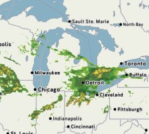
So far today, we have received quarter of an inch of rain, and we’re being warned that more is on the way. It has ranged from steady to moderate most of the morning, but it isn’t raining right now. Radar is showing a break for a while with more coming later. We really don’t need anymore and could easily go a week without.
Our 1:45 PM temperature is 59°F, the humidity is 90%, and skies are overcast. Winds are from the ENE at 0-3 mph, and the pressure is 29.33 in and falling. The dew point is 57°F and visibility is 5 miles. Yesterday’s high was 65°F and the overnight low was 50°F. Average temps for this date are 72°F/49°F. Sunrise was at 6:52 AM and sunset will be at 8:09 PM.
DURAND / OWOSSO FORECAST:
This Afternoon: Showers and a possible thunderstorm. Highs in the lower 60°s. Patchy fog developing late in the afternoon. Winds ESE at 5-10 mph. Chance of rain 70%.
Tonight: Showers becoming steady rain overnight. Thunderstorms possible. Lows in the upper 50s. Patchy fog late. Winds east at 5-10 mph. Chance of rain 80%.
Sunday: Cloudy with a chance of rain early. Mostly cloudy in the afternoon with highs in the mid 60s. Winds NE at 10-15 mph. Chance of rain 30%.