Too Much Rain . . . . .
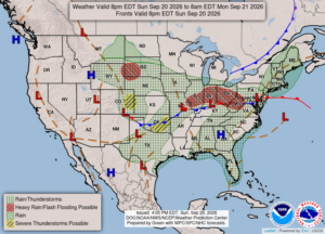
After a rainy Saturday, today started out the same. Now we have an occasional sprinkle but radar is showing most of the rain well to our south. The states just to our south are getting severe flooding with training storms moving over them most of the weekend. Once again, we have been lucky.
Our 4:30 PM temperature is 66°F, the humidity is 87% and skies are overcast. Winds are from the SE at 2-4 mph, and the pressure is 29.91 in and steady. Yesterday’s high was 72°F and the overnight low was 58°F. Average temps for this date are 72°F/49°F. Record temps for Sept. 19 are 86°F (2025) and 32°F (2014). Sunrise was at 7:22 AM and sunset will be at 7:39 PM.
DURAND / OWOSSO FORECAST:
This Afternoon: Cloudy with highs in the mid 60s. Winds are from the NE at 10-15 mph. The dew point is 59F and visibility is 10 miles.
Monday: Mostly cloudy. Highs in the low 60s. Winds NE at 10-15 mph gusting higher at times.
Monday Night: Becoming partly cloudy. Lows in the mid 40s. Winds NE at 10-15 mph.